Earthquakes have a reputation for causing chaos—and sometimes, they turn the solid ground beneath our feet into a moving, unpredictable force. But have you ever stopped to wonder how earthquake depth of focus and epicenters are determined? It’s a bit like detective work, but instead of tracking clues in a city, scientists hunt for the exact spot inside the Earth where things started to go haywire.
I’ll confess: When I first learned how seismologists pinpoint these locations, I was amazed at the blend of math, pattern recognition, and raw human curiosity involved. It’s not just about watching a shaky needle on a graph. There’s careful reasoning, clever technology, and a surprising amount of teamwork. Let’s break open this mystery, step by step—no jargon overload, I promise.
Table of Contents
- Why Depth and Epicenter Matter
- Epicenter vs Focus: The Basics You Need
- Catching the Quake: How Seismographs Work
- Step-by-Step: How Earthquake Depth of Focus and Epicenters Are Determined
- A Real-World Case: The 2011 Japan Earthquake
- Patterns, Surprises, and What the Data Shows
- Pros and Cons of Current Methods
- FAQ: How Earthquake Depth of Focus and Epicenters Are Determined
- A Human Reflection
Why Depth and Epicenter Matter
Let’s start with a small, but important question: Why should any of this matter to us? Well, the location—and more specifically, the depth and epicenter—of an earthquake changes almost everything about its effect on people and the landscape.
- A shallow earthquake (say, 0–70 km deep) packs more punch at the surface than a deep one way down in the Earth’s mantle.
- Knowing the epicenter can help emergency teams focus rescue efforts, especially in sprawling cities or remote villages.
- Patterns of depth and epicenter locations help us spot dangerous fault lines—like warning beacons for future quakes.
According to the US Geological Survey, about 90% of all earthquakes happen at these shallower depths. That’s why depth and epicenter are reported in every news story—sometimes within minutes of a quake.
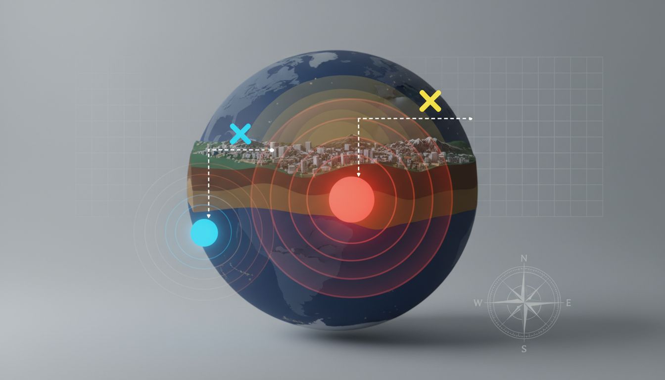
Epicenter vs Focus: The Basics You Need
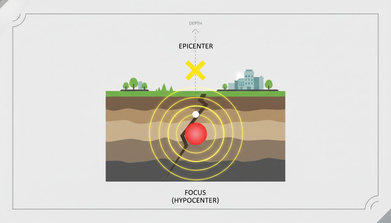
This is where many people get tripped up, and honestly, I did too at first. Here’s the simplest way to describe it:
- Focus (or Hypocenter): The exact point inside the Earth where the earthquake starts. Think of it as the “origin” or starting gun.
- Epicenter: The spot directly above the focus on the Earth’s surface. If you could draw a straight line up from the focus to the ground, that’s your epicenter.
So, the focus is like the bulb in a flashlight—deep inside somewhere—while the epicenter is where the beam shines onto a wall. Easy enough, right?
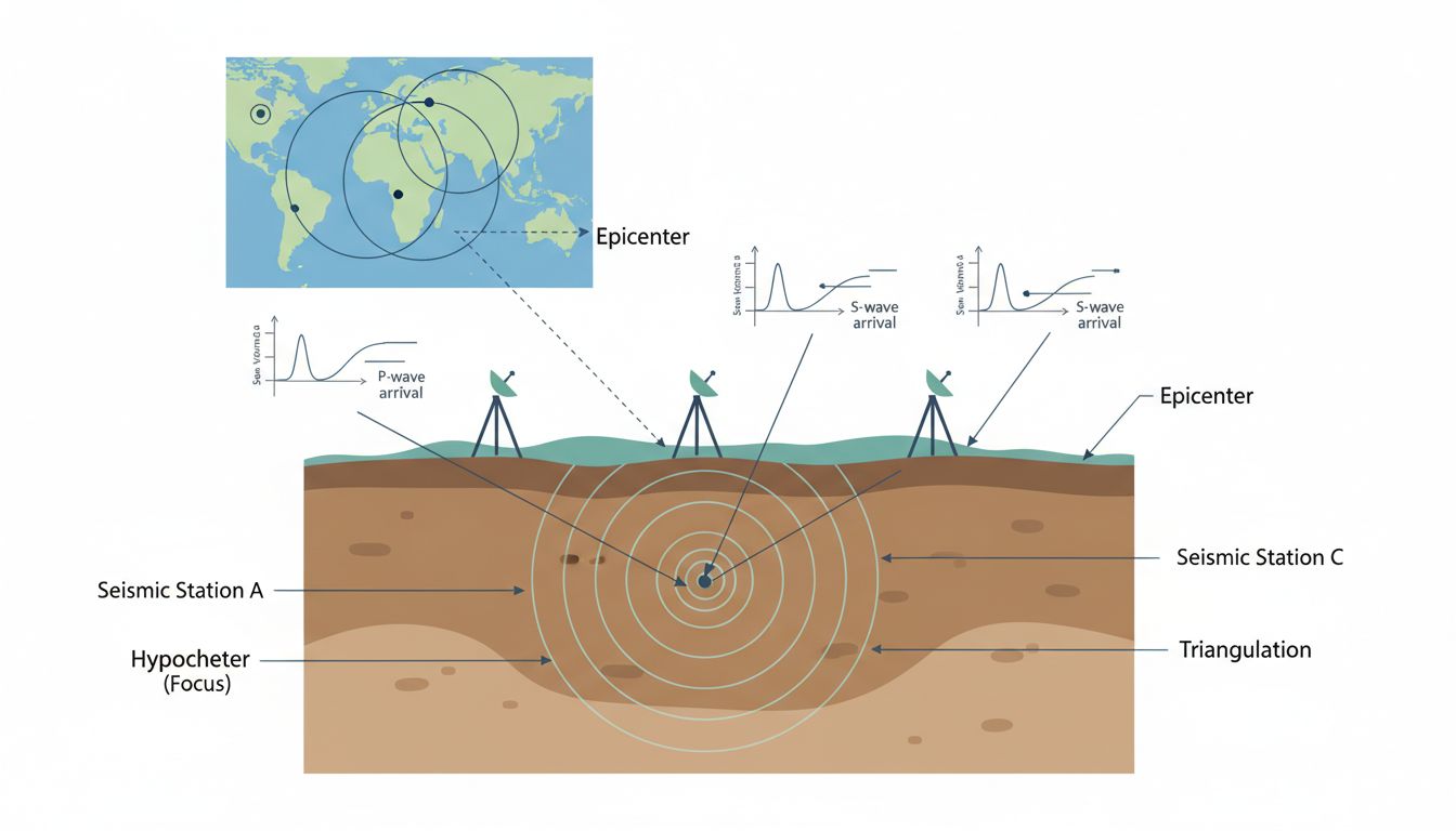
Catching the Quake: How Seismographs Work
Before anyone can figure out how earthquake depth of focus and epicenters are determined, they need evidence. Enter the seismograph.
I’ve visited a local science museum where they let kids (and curious adults like me) jump next to a working seismograph. The sensitive instrument scribbles out zigzag lines when the ground vibrates. But in real life, seismographs are stationed all over the world—quietly listening for the subtle (or not-so-subtle) rumblings of our planet 24/7.
Here’s a quick breakdown:
- A quake sends out seismic waves in all directions. The fastest are P-waves (primary), followed by slower S-waves (secondary).
- Seismographs detect and record the exact arrival time of each wave.
- By comparing the time gap between the P and S waves at different stations, scientists can start to figure out where the quake began.
This is where the real detective work begins.
Step-by-Step: How Earthquake Depth of Focus and Epicenters Are Determined
1. Collecting Data from Multiple Locations
Let’s imagine an earthquake shakes a city. Seismographs in different towns record the event. Here’s the trick: The farther you are from the earthquake’s source, the more time there is between the arrival of the P-wave and the S-wave. It’s sort of like hearing thunder after seeing lightning—the further away the storm, the longer the delay.
Scientists typically need information from three or more seismograph stations to pinpoint the epicenter. More stations equal better accuracy—sometimes down to within a kilometer, which is frankly impressive given the scale of our planet.
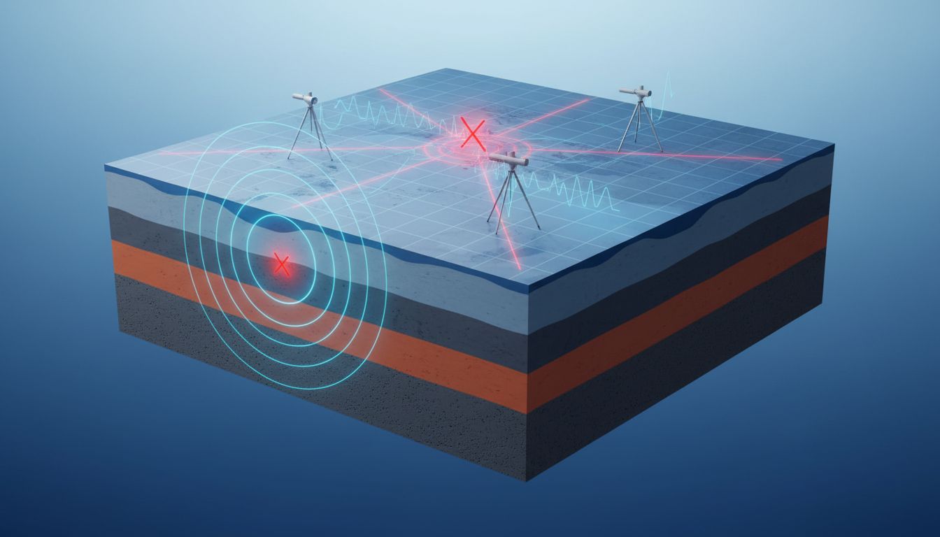
2. Triangulation: Drawing Circles on Maps
At each station, seismologists estimate how far away the quake was, based on those P- and S-wave time gaps. Then they draw a big circle around each station. Where the circles meet is the epicenter.
This method is called triangulation, and it’s as old-school as it is effective. If you’ve ever done a scavenger hunt with maps, you’ve used a similar process!
3. Calculating the Depth of Focus
Determining the depth is a bit more complex. Here’s a simplified version:
- Scientists use the speed of seismic waves (which changes with depth) and compare arrival times at various stations.
- They look for patterns—waves that are delayed or distorted in specific ways due to traveling through deep versus shallow rock.
- Computer models then test different depth scenarios until the data matches up perfectly.
On average, this whole process—from quake to full analysis—can happen in less than 20 minutes. With today’s technology, initial results can pop up on your phone before you’ve even finished wondering, “Was that an earthquake?”
A Real-World Case: The 2011 Japan Earthquake
Let’s bring this process to life with a famous example: the 2011 Tōhoku earthquake in Japan.
- Magnitude: 9.0
- Focus depth: About 29 km (shallow, by seismic standards)
- Epicenter: Off the coast of Honshu, Japan
Within minutes, seismographs across Japan and even in California started picking up the quake’s waves. Using data from hundreds of stations, scientists triangulated the epicenter to a patch of seafloor. The shallow focus made the quake devastating—causing a deadly tsunami and massive damage along the coast.
What’s stunning is how quickly the world knew: the location and depth were broadcast globally in under half an hour. It’s a somber reminder of the power of nature—and the power of human ingenuity in responding to it.
Patterns, Surprises, and What the Data Shows
Now, let’s look at some patterns and surprises in real earthquake data:
- Over 85% of destructive earthquakes have a focus shallower than 70 km. That’s why depth is often more important than magnitude when it comes to damage.
- Deep-focus earthquakes (more than 300 km down) are rare, but they do happen—often in places like the western Pacific, where tectonic plates dive steeply under one another.
- Clusters of epicenters can reveal hidden fault lines. For example, the infamous San Andreas Fault is mapped largely by observing countless epicenters over decades.
Here’s something people often miss: Small, deep quakes (hundreds of km down) usually don’t cause surface destruction, but they’re crucial for understanding the slow, grinding movement of our planet’s plates. These events give geologists hints about what’s happening far beyond our reach.
If you look at earthquake maps (you can check out live updates at earthquake monitoring sites), you’ll notice how certain regions, like the Pacific “Ring of Fire,” are lit up with epicenters—proof that the Earth’s crust is always in motion.
Pros and Cons of Current Methods
Pros
- Reliability: Triangulation is simple, fast, and has stood the test of time.
- Speed: With dense seismic networks, epicenter and depth data can be released within minutes.
- Global Coverage: Even remote regions are now monitored by international networks.
Cons
- Accuracy Gaps: In areas with few seismographs, pinpointing depth can be tricky—sometimes off by several kilometers.
- Technology Needs: Advanced modeling and rapid alerts require big data and powerful computers.
- Subsea Quakes: Underwater earthquakes (like those that cause tsunamis) can be harder to analyze due to fewer deep-sea sensors.
I sometimes wish every city, from bustling capitals to tiny island villages, had the same seismic coverage. But progress is steady—even the most remote corners of the globe get a little less mysterious with every new sensor we install.
FAQ: How Earthquake Depth of Focus and Epicenters Are Determined
How fast can scientists determine the epicenter of an earthquake?
Usually within 5 to 15 minutes for most areas with modern networks! For major quakes near dense sensor arrays, initial data can be released even faster. But in remote or poorly monitored regions, it may take longer—sometimes hours for detailed analysis.
Why are some earthquakes more destructive even if their magnitude is lower?
It often comes down to depth. Shallow earthquakes (less than 70 km deep) send shockwaves straight to the surface, causing more shaking and damage. Deep quakes, even if strong, lose much of their energy before reaching people and buildings.
Can we ever predict earthquakes by watching epicenter patterns?
Not at the moment. While mapping epicenters helps spot risky faults or “hot zones,” it doesn’t let scientists predict when a quake will happen—only where it might be more likely. Earthquake prediction remains one of geology’s great challenges.
Is it possible to feel a deep-focus earthquake?
Sometimes, but it’s rare. Deep-focus quakes (over 300 km deep) usually produce gentle, wide-spread shaking—not the sharp jolt of a shallow quake. Most people barely notice, unless it’s a truly massive event.
How do scientists handle earthquakes that begin under the ocean?
Special underwater seismometers, satellite data, and even tsunami buoys help fill in the gaps. It’s a tougher job, but technology is improving every year. After the 2004 Indian Ocean tsunami, many countries invested in denser ocean monitoring to better spot undersea quakes.
A Human Reflection
When I watch news flashes about distant earthquakes, I’m always struck by how quickly and precisely the world’s scientists can tell us exactly where, and how deep, the ground has slipped. It’s a reminder that beneath all the sophisticated equipment and number crunching, there’s a kind of empathy—a drive to understand, warn, and protect people from nature’s sudden surprises.
So next time you see those statistics—magnitude, depth, epicenter—remember the detective work, the circles drawn on maps, and the passion of those quietly listening to the Earth’s heartbeat. In a way, every seismograph is a tiny ambassador, bridging the gap between the mysterious world beneath our feet and the lives we lead on its surface.
Curious to see the world’s latest quake epicenters in real time? Browse live maps through services like the USGS Earthquake Hazards Program. The story of the Earth is always being written—and you can watch it unfold, one ripple at a time.